Pages

Showing posts with label hiking. Show all posts

Monday, September 26, 2011

Mills Peak Fire Lookout


Our annual trip to "Camp Rutabaga", also know as Diablo Campground near the Sierra Buttes - was delayed till September this year.  Last weekend we finally got into the Sierras for some camping, hiking and tall tales.  After huge snowfall last winter, there was snow on the ground and on the trails much later than usual this summer.  A friend who intended to hike for a month on the Pacific Crest Trail beginning in April had to cancel his sabbatical.  Too much snow made the trail impassable.

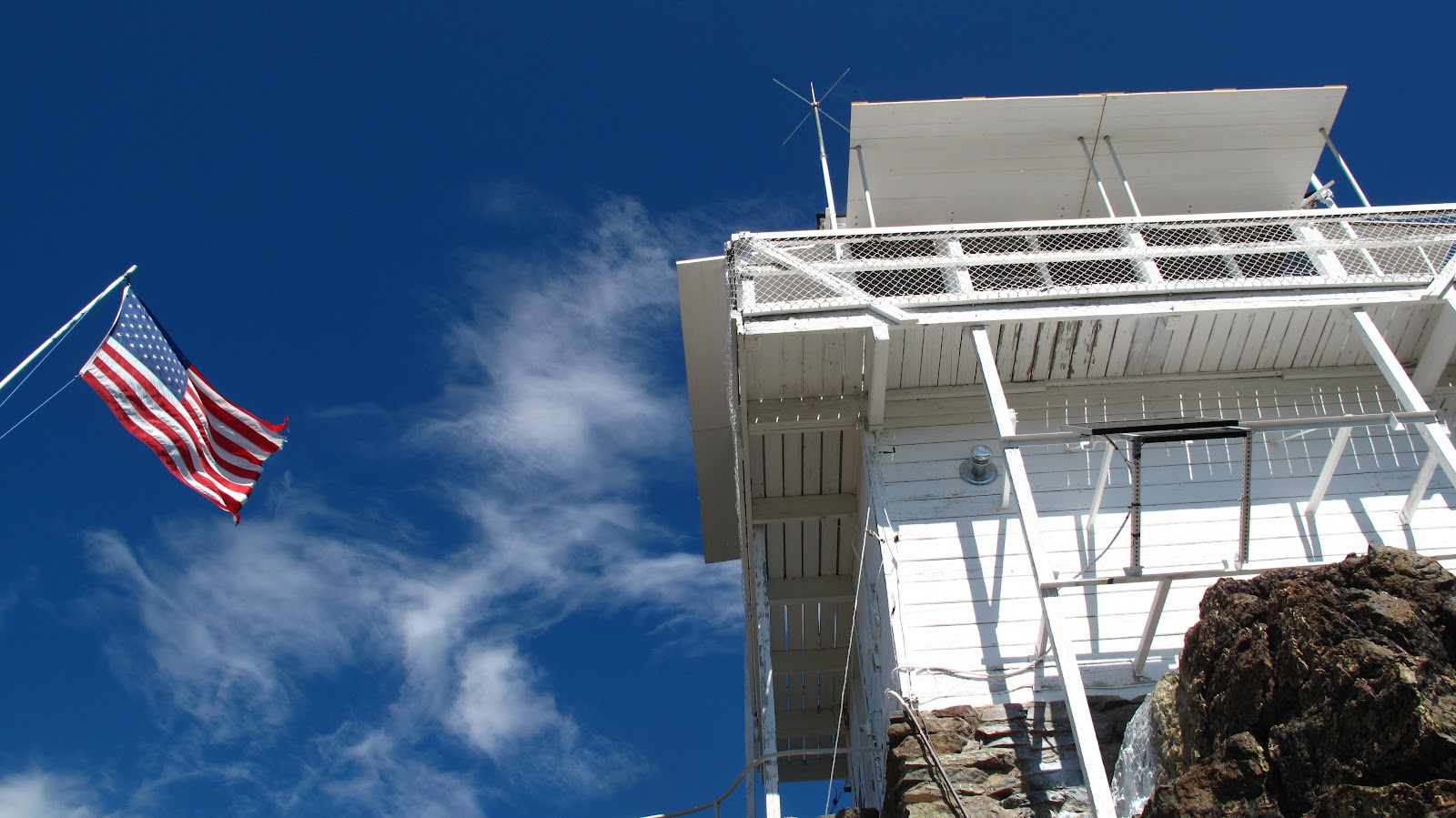
We went up to Mills Peak fire lookout station and found a "manned" fire lookout.  The building was built in the 1930's and has weathered the severe conditions very well.


I spent some time talking with the Ranger who also "manned" the fire lookout.  He said that there would probably be over 150 visitors on this beautiful September Saturday.  Through the glass you can see him looking off toward the northwest with his binoculars.


There is a panoramic view of this lakes region of the Sierras.  The Sierra Valley, source of the Feather River is easily visible to the east, with Mount Lassen visible to the north.

It's hard to believe that we have come back to this area the past four years, and had not been up to Mills Peak.  What other treasures lie waiting in these mountains?

Enhanced by Zemanta

Sunday, June 19, 2011

Banana slugs in Napa

Napa County banana slug


On Saturday morning members of our Rotary Club were invited by one of our members to hike in the Moore Creek Preserve in Napa County.  This is a piece of property that will be part of the Napa County Open Space District.  The creek drains into Lake Hennessey, the largest water supply reservoir for the City of Napa.  The lake is located in the eastern hills of the valley near Conn Creek Rd. and the Silverado Trail, off of highway 128.
                                                             
Very unexpectedly, we came across banana slugs.  In 2009 we had a delightful hike in the redwood forest of Santa Cruz County - but Napa County is not a "coastal" county in California.  And our remnant redwood forest is predominantly on the west side of the valley, with a stand of redwoods near Angwin that are reputedly the easternmost redwoods in California.  Banana slugs seem to live in conifer forests.  While there are some second growth fir trees in the Moore Creek Preserve, this is not a redwood habitat.

It is beautiful country, with a still running creek in the bottom of the canyon, heavy oak/madrone/maple and fir forest - surrounded by steep hills covered with oak savannah.
The trail is rough and not quite finished.  The park will open next year - we hope in the spring.  The trail we took is partly an old logging road which crosses the creek a half-dozen times.  My feet were damp after the second crossing.


 Some of the banana slugs we saw were spotted like old, overripe bananas.  Their color was muted, not the pure electric yellow of the ones we saw in Santa Cruz at Big Basin Redwood Park.  Still, they are a sight I never expected to see on this little hike.

I also did not expect to see wildflowers, but a few clung to the edges of the trail and to the rocks of the hill.  Ferns filled the low areas next to the creek. 

There seemed to be some seams of serpentine rock, and a wild mix of trees that included gray pines - which like serpentine soil.  We missed the presence of Craig and Millie, birders who could identify all the birds we heard.
We had a jolly crew on the hike.  I had a weird realization today as I sat down to write.  I think I was the eldest member of the group. 

I'm sure this earns me no special distinction, but I was winded on the steep sections of the trail and obviously need more conditioning before setting out on a major hike.
John kept me company as I gradually started to fall back in the group.  I could always use "taking photographs" as an excuse for slowing down, but actually started to feel pain in my repaired hip.  

Thanks to John our host and guide for homemade oatmeal cookies when we got back to our vehicles.

Enhanced by Zemanta

Monday, August 16, 2010

Morning light


Early morning light in the campsite - enough to read by. John McPhee's book, "Assembling California" is a fascinating account of geological explorations of California. It explains why we have gold here, what serpentine rock is, and why we have earthquakes. The route up to the Yuba Pass area traverses all the zones discussed in the book.


We decided to take a hike from the Tamarack Lakes area over a high trail pass, then down to the Sardine Lakes. Jasmine fetched sticks and had a vigorous swim:


Lilly John


The ladies in green amongst the wild flowers watched and chatted about bunnies.


A shocking turn of events happened as we started on the trail and Jasmine was attacked by one of a pair of Malamutes. Her face and ear were torn, but there was no heavy bleeding. We pampered her over the rest of the hike, and John and I dropped back as we let her rest in patches of shade. Her age (now 10 years) started to show as she slowed the pace. The extreme rockiness of the trail was hard on her paws. The route was about 4.6 miles - up about 700 feet, then down about 800 feet.


It's a long way down to the lakes - Lower Sardine on the left and Upper Sardine on the right. The trail comes out at about 7500 feet of elevation, well below the peaks beyond. We passed the "Young American" mine ruins below the trail. The trail began to look more and more like a narrow mining trail suitable for ore carts. Across the valley with the lakes are the Sierra Buttes. On the tip of the highest peak is an old fire lookout station:


We returned to "Camp Rutabaga" hot, dusty, torn and worn.


Enhanced by Zemanta

Saturday, August 14, 2010

Yuba Pass and the Feather River


In the Sierra Valley high in the Sierra Nevada Mountains is the source of the Feather River. On our way to camping at "Camp Rutabaga" near the Yuba Pass we went off-road on a ranch road and found the source of the Feather River. This high valley wetland harbors Sand Hill Cranes and Black Angus.


They look so natural together.


Ducks, barbed-wire, pick-up trucks and clear mountain air got us started off on a mountain camping get-away.


Enhanced by Zemanta

Saturday, April 3, 2010

not basketball

It finally dawned on me why today was a particularly lovely and uncrowded day to learn about heirloom tomatoes from wildboar farm and to hike in Sonoma County Sugarloaf Ridge Park. We were not watching basketball. Walking down the sidewalk in the town of Sonoma at the end of a busy day I overheard a woman telling her husband that Butler was in the final four. Logging into facebook this evening a high school friend commented that she was going to grudgingly root for Duke. From these two scraps of information I expect that the final game is Butler vs. Duke. We shall see...


Meanwhile, we spent the day learning about heirloom tomatoes from a local grower and hybridizer, finding such interesting varieties as Berkeley Pink Tie-dye. Chuck and Felicia came to the class to learn more about how to grow great tomatoes. We shall see if the advice improves our tomato crop this year. We have so many small plants that we will need to host a tomato festival in September.


After "class" we went with friends Craig and Millie to Sonoma County to hike in one of the state parks, hoping to see birds and wildflowers. We saw turkeys taunting us because they seemed to know that they were in a protected zone and no spring turkey hunting season applied to them.

There were some early wildflowers, but they seemed a bit confused by the weather that has been very warm, then freezing, now wet, and finally a day of sun.


Views from the Sugarloaf Peak trail are stunning. In such an intensely farmed region, there were only a couple of hillside vineyards visible from the trail, and none from this view looking over the Sonoma Valley north of Kenwood.


There were wildflowers and lichens:


I was struck by the color contrast of the madrones and manzanitas in this greenscape. Ireland must be as lush and green as this landscape. But clinging to the hills are also these richly colored California natives.

Please forgive the formatting anomalies. "Scribefire" and blogger are both being difficult.

Monday, September 14, 2009

Sierra Buttes and Yuba Pass

After months of walker, crutches, cane, physical therapy and "rehab.", I was able to return to the Sierras to hike on the remodeled hip. My goal was to get back on the trail by the end of summer, and by my accounting, Labor Day weekend still counts officially as "summer". Over the long weekend John and I met friends Francois, Gerda, Melt, Bob and Karen to camp at the Diablo campground near Sardine Lake. Melt towed Francois' classic Jeep up to the home base campsite, and we took this amazing little mule up a logging/fire trail part of the way up to the Sierra Buttes. We then hiked the rest of the trail up past the Pacific Crest Trail to the fire lookout on the top of the Sierra Buttes.

The Sierra Buttes are ancient rock formations that have fist to head-sized cobbles metamorphosed into a composite showing a range of colors and cobble types. These aren't little bitty crystals.


The top of the Buttes has a fire lookout station perched on the crest, with precarious steel stairs anchored into the rock.


The views are stunning in every direction, and as the highest point in this part of the mountain range, it's all downhill from here.


Even on a sunny day, we're bundled up for the wind - puffy purple vest for me, and fur coat for Jasmine!

Sunday, July 26, 2009

Yosemite

Living in California it is hard to imagine not having visited Yosemite; but this year another brother, John, and his wife Patti visited - and asked if we would like to go to Yosemite with them. We took a whirlwind trip up to the high country to show them the highlights of this vast park. It's an impossibility, though. Most visitors see the Yosemite Valley, but see none of the high country, the giant sequoia groves, Hetch Hetchy, the Tioga pass, the high alpine lakes, the charming historic Wawona Hotel. Ah, well, we did the best we could in two days.


The Merced River


Being a fan of all things historical, I took them to the Ahwahnee Hotel.


Patti, John and Anna at the first overlook...


And here's Patti enjoying a little light reading in the Ahwahnee lobby.


Finally,a little hiking... and I got to try out the new and improved hip joint.


Reblog this post [with Zemanta]

Friday, May 22, 2009

Roadies and Rhodies


On our current road trip to Oregon to seek out irises and peonies, we stopped near McKinleyville at the Azalea State Natural Reserve. I had never seen these soft pink native azaleas (Rhododendron occidentale) before.

The reserve seems a neglected little corner of the California State Park system, and I expect that the spot is rather forlorn most of the year. But this week, the azaleas are in bloom, and in a few locations can be seen in proximity to similarly sized native ceanothus, also in bloom. Late May is the time to see these plants.

Sunday, March 1, 2009

Banana slugs and fungi

Just for a little truth in labeling, this post includes banana slugs and fungi. There are also waterfalls, redwood trees and undulations.

Yesterday we had a spring walk in the woods at Big Basin Redwoods State Park. Note that the trail description says that the elevation is 200-400 feet. Seems easy enough, although the trail is labeled "strenuous". It turns out that the 2-400 foot elevation change happens about 12 times in the 12 mile loop we took. These turned out to be "undulations" or extremely large sine waves. Otherwise, a delightful day in the redwoods hunting fungi, banana slugs and waterfalls. We went to the Berry Falls, Golden Falls and Silver Falls - here's a copy of the official park map.


Berry Falls

Along the way we found lots of fungi sprouting from downed trees and vegetable detritus. Colors ranged from virulent green to pink and dayglow yellow/orange. I'm sure they all have names.


Chuck, Felicia, Francois, John and I were the group. By about the half-way mark, my bum hip began to give trouble - so our return trip was a rather leisurely stroll for the seasoned hikers of the group.

We lunched at the base of the first (and highest elevation) falls of the group on West Berry Creek. John, having hiked the trail several times, did not reveal the delights in store. Especially the rappelling down the face of one of the falls. I asked, "is there another way down?" and John's one word answer - "No." Hmmm... 6 miles up a creek with an airplane cable to hold on to to get down. I guess I'd rather do that than try to walk back around...

We were truly stumped a few miles down the return trail where a pair of redwood trees had fallen across the path giving a chest high by 200 foot long barricade. Up and over, or down into the canyon to go around? We tried several methods and all emerged on the other side of the barrier.

The UC Santa Cruz mascot was thundering through the mosses...


...and fallen and fire scarred trees gave contrasting texture and color to the wet green canopy of the forest.


On the way home to Napa, exhausted and hungry (at least the hungry part was true of all of us) we stopped in Albany/Berkeley for the best pizza in the Bay area - Zachary's.